| 6,000 m range |
| Distance, Azimuth and Elevation measurements |
| Measurements between two objects |
| Rugged and compact design |
| Android™/Bluetooth Compatible |

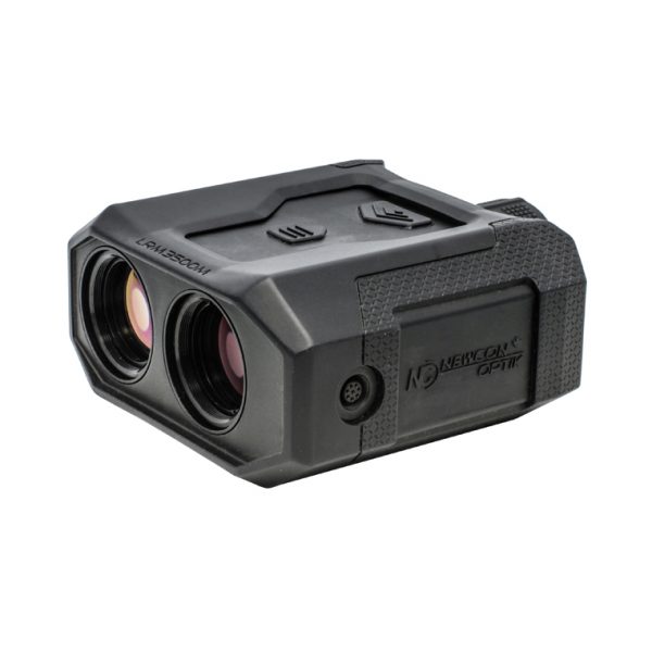
The LRM 3500M-35BT is the world’s most advanced miniaturized laser rangefinder monocular. Weighing just 460 grams, the LRM 3500M-35BT is capable of measuring distance to targets out to 6 kilometers, but what truly sets this device apart from the rest is its built-in GPS receiver allowing for user and target coordinate measurement, digital magnetic compass, inclinometer, bright LED display, Bluetooth capability, Kestrel ballistic calculator and fully ruggedized design. Users can now communicate with the LRM 3500M-35BT using Newcon Optik’s new NC Cronus app. The LRM 3500M-35BT is the ideal tool for professionals who depend on the accuracy and ruggedness of their equipment to get the job done.
This device is compatible with:
![]() Android™
Android™ ![]() Bluetooth™
Bluetooth™ ![]() Ballistic app
Ballistic app ![]() NC Cronus™
NC Cronus™ ![]() CivTAK/ATAK
CivTAK/ATAK
| 6,000 m range |
| Distance, Azimuth and Elevation measurements |
| Measurements between two objects |
| Rugged and compact design |
| Android™/Bluetooth Compatible |
|
Part Number |
NC-35BT |
|
Optics |
|
|
Magnification (x) |
6.5 |
|
Objective lens diameter (mm) |
30 |
|
Field of view (°/mil) |
7/124 |
|
Eye relief (mm) |
20 |
|
Diopter adjustment range |
±5 |
|
Rangefinder |
|
|
Eye safety |
Class 1, eye-safe |
|
Peripheral Compatibility |
Bal Comp, AFS, PC, BT, AndroidTM, Available plug-ins for CivTAK/ATAK |
|
Wavelength (nm) |
1550 |
|
Measuring distance range (m) |
10 – 6,000 |
|
Specified measuring distance range (m)* |
10 – 3,500 |
|
Inclinometer range (mils) |
±1420 |
|
Distance measurement accuracy (m) |
±1 |
|
Distance units |
m/yds |
|
Azimuth measurement accuracy (mils) |
± 17.5 (Optional ±10) |
|
Inclination measurement accuracy (mils) |
± 8.8 (Optional ±5) |
|
Speed detection |
– |
|
Magnetic declination correction (mils) |
– |
|
Compass & inclinometer units |
°/mils |
|
Power-on time (sec) |
< 1 |
|
FOS (Fall of shot) |
– |
|
First/last target logic |
Yes |
|
Target discrimination (m) |
50 |
|
Scan mode |
Yes |
|
Last 10 readings recall |
Yes |
|
Distance between objects |
Yes |
|
Horizontal distance between objects |
Yes |
|
Azimuth difference between objects |
Yes |
|
Inclination difference between two objects |
Yes |
|
Height difference between objects |
Yes |
|
Etched reticle step (mils) |
1 |
|
Etched reticle range horizontal/vertical (mils) |
120/60 |
|
User GPS coordinates |
Yes |
|
Target GPS coordinates |
Yes |
|
GPS coordinates format |
Dec Degs Micro |
|
Mechanics, Electronics & Environmental |
|
|
Display type |
Customized Matrix Red OLED |
|
Interface |
USB, Bluetooth |
|
DAGR communication |
– |
|
Dimensions with no sleeve (mm) |
118x107x54 |
|
Weight without batteries and sleeve (g) |
385 |
|
Power supply |
Non-magnetic 2x CR123 Lithium batteries |
|
Battery life (# of measurements) |
5,000 |
|
Low battery indicator |
Yes |
|
Tripod mountable |
Yes |
|
3-axis digital compass |
Yes |
|
Compass calibration & validation |
Yes |
|
Operating temperature range (°C) |
-35 to +65 |
|
Storage temperature range (°C) |
-40 to +85 |
|
Waterproofing |
MIL-STD-810G (1m/30min) |
|
Mechanical & optical compatibility with NVS14 and PVS14 night vision devices |
Yes |
*2.3×2.3m NATO standard target